Routes and Starting Location
Many changes have been made to the Tierra Bella routes recently! All routes end with post-ride festivities and parking at Christmas Hill Park.
Mileage and climbing is approximate and subject to change.
Route Descriptions
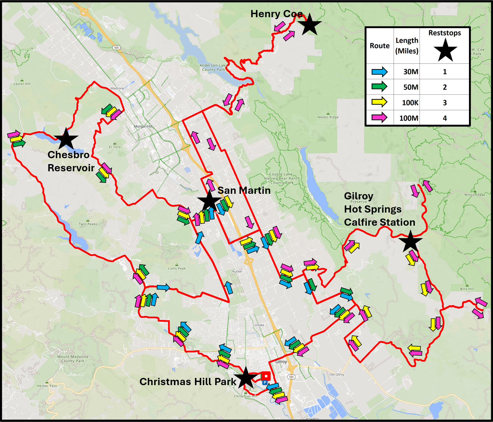
Click on the map to see a larger version. Full-size maps will be available at the registration desk. RideWithGPS routes will be provided by email before the ride.
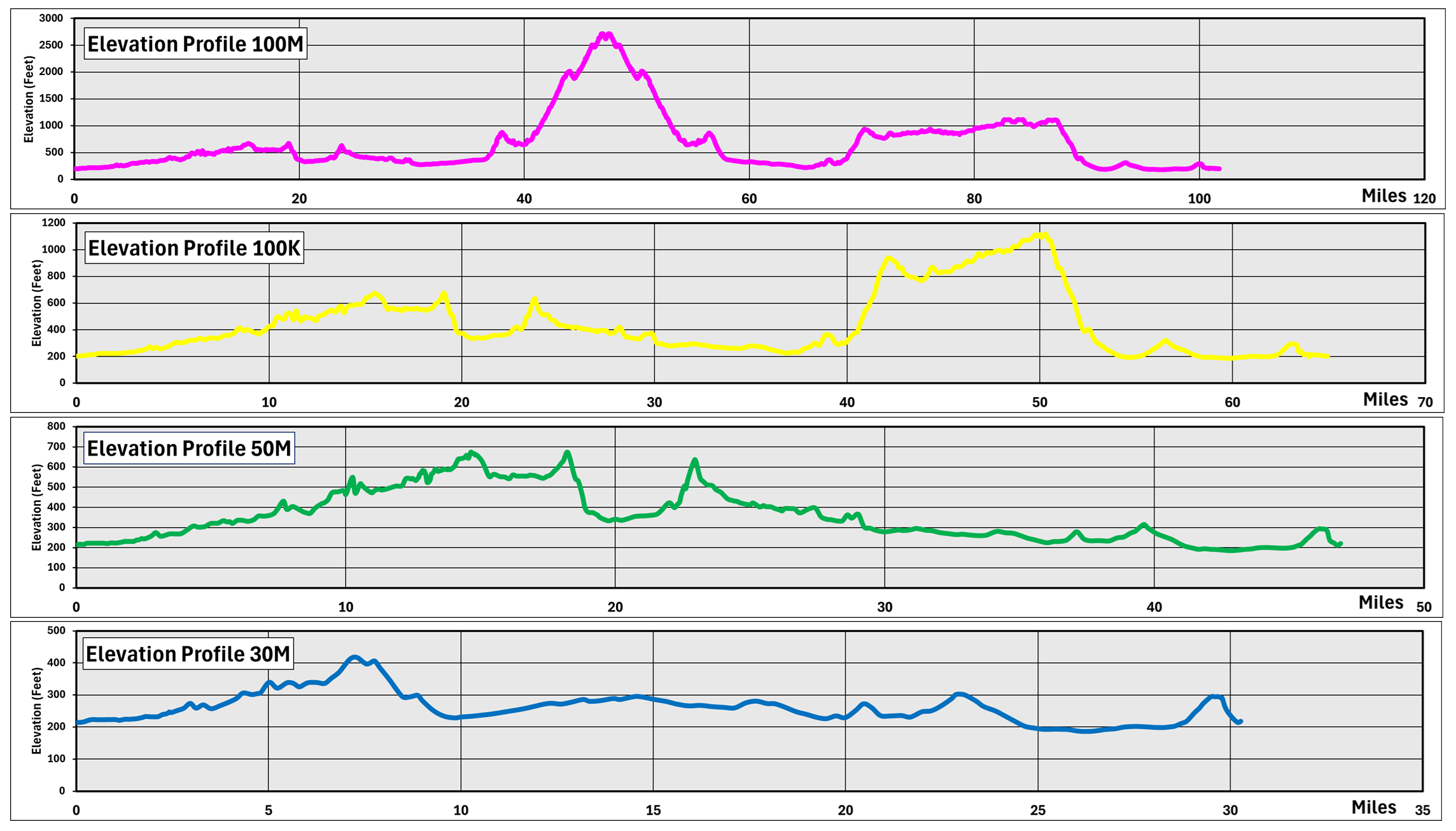
Click on the profile to see a larger version.

Starter (30M): ~30 miles with 702 feet of climbing
A great route for beginners, family, or cyclists who couldn’t get much riding in during the winter, this relatively flat loop meanders from Gilroy to San Martin. The route starts heading west along a bike path then north out of Gilroy past pastures and vineyards to a rest stop in San Martin. It then returns to Gilroy via the east valley along rural roads, ranches and farms. Follow the Blue arrows.
Half-century (50M): ~47 miles with 1,725 feet of climbing
This route starts with a loop northwest, riding along rolling roads past both Uvas and Chesbro Reservoirs. After a stop at the Chesbro Reservoir you get a bit of up and down on short quiet hills north of Morgan Hill, then to a rest stop in San Martin before returning through ranch and farmland east of Gilroy back to the start. Follow the Green arrows.
Metric Century (100K): ~65 miles with 3,024 feet of climbing
John Muir walked here! This route starts off following the same route as the Half Century around Uvas and Chesbro Reservoirs and some short hills on Willow Springs and Llagas in Morgan Hill before heading back south to a mid-ride rest stop in San Martin. It then takes you on the historic climb up to Gilroy Hot Springs where John Muir first walked from San Francisco to Yosemite in 1868. A frozen-in-time pastoral loop, descent of Canada Road, and across the farmland lead you back to the finish in Gilroy. Follow the Yellow arrows.
Century (100M): ~102 miles with 6,712 feet of climbing
This century ride combines all the options from the above routes plus the challenging climb up to Henry Coe State Park. You start by following the same route at the Metric Century around Uvas and Chesbro Reservoirs, down Willow Springs and up Llagas Road to the mid-ride rest stop in San Martin. From there you head back north to Morgan Hill and the climb up Dunne Avenue to Henry Coe Headquarters. After the descent you head south to Gilroy and follow the footsteps of John Muir on the climb up to Gilroy Hot Springs. Much of this loop around Canada Road with a beautiful out-and-back into the pastureland on Jamieson Road has not changed for a century, a fitting route for a Tierra Bella Century Ride. After the descent, you cross through farmland to the finish in Gilroy. Follow the pink arrows
We use “Ride With GPS” mileage and climbing totals. We will provide RideWithGPS downloadable routes to registered riders as the date approaches. These routes may be used off-line with the RideWithGPS smartphone apps and other GPS units.
Starting Times
Please plan to start your ride according to the following schedule:
| 100M (pink) route | 6:30 to 7:30 AM |
| 100K (yellow) route | 7:30 to 8:30 AM |
| 50M (green) route | 8:30 to 9:30 AM |
| 30M (blue) route | 9:30 to 10:30 AM |
We have support from volunteer mechanics and local bicycle shops (details subject to change).
Parking & Accommodations
The yellow (100K) and pink (100M) routes start at Gilroy High School. The blue (30M) and green (50M) routes start at Christmas Hill Park, Gilroy CA. All riders, please visit our early check-in or stop by the registration desk at Gilroy High School first!
Vehicle parking for riders doing the blue (30M) or green (50M) routes will be at the Christmas Hill Park. Parking for riders doing the yellow (100K) or pink (100M) routes will be at the Gilroy High School student lot and/or streets nearby off Princevalle St at Johnson Way.
Parking volunteers in reflective vests will be present to assist and direct you to the appropriate lot. Carpools are encouraged!
Parking is limited and free. Please rely on our friendly, helpful parking staff (in orange safety vests) to direct you, including to our overflow lots. Carpools are encouraged.
There is no overnight parking or camping at Christmas Hill Park. For a list of local motels and campgrounds, please see FAQs for links to lodging facilities.
Our start locations are about 35 miles south of San Jose. If you are heading south on Highway 101 from Gilroy, take exit 356 for 10th St/CA-152 E and follow our parking volunteers' instructions.
If you are approaching Gilroy from the south, take exit 356 for 10th St/CA-152 E, and follow our parking volunteers' instructions.